

Who and to what extent uses the waters of the Syr Darya and Amu Darya, or how to prevent future droughts?
According to the UN, more than 20 liters of water per day per night are required for normal human life, and another 50 liters for use in sanitation systems. Now in the world 1.1 billion people consume about 5 liters of water per day. In European countries, however, it is mentioned as a fact that each person consumes 200 liters of water per day, and in the USA 400 liters. This means much more than normal. It is estimated that by 2025 there will be 3 billion water shortages worldwide. By this time, they need less water compared to the minimum amount of water used by humans. Now in the world there are 261 states in the river basin. This territory occupies 80% of the world's river basins and 45.3% of the Earth's surface. It is home to about 40% of the world's population.
With the growth of the population in areas with a warm climate, the process of desertification intensifies. Desertification is currently affecting the way of life of 100-200 million people worldwide, forcing more than 50 million people to leave their habitats within the next decade. The economic damage from this is estimated at 42 billion US dollars. Global climate change may also change this process.
In addition, at present, the world's population, along with desertification, is concerned about the problem of lack of fresh water.
In more than 20 states out of about 50 river basins, there are heated debates at the level of heads of state about the use of water, its proper distribution. For example, the economy of the Egyptian state with a population of more than 70 million people is completely dependent on the Nile River. Despite the fact that the delta of this river is located in Egypt, 90% of its water comes from the territory of the states of Sudan, Abyssinia and Uganda, located in the upper reaches of the river. In accordance with the 1959 agreement, the Egyptian state received 55.5 billion m3 of water per year, and Sudan 18.5 billion m3. Abyssinia is pushing for a revision of water distribution in protest against this quota.
The Republic of Uzbekistan in the 70-80s of the last century annually received 74.1 km3 of water from the Amu Darya and Syr Darya, of which 28.4 km3 fell on the Amu Darya, 10.9 km3 on the Syr Darya, 19.2 km3 on internal small rivers , 12.6 km3 - for underground and collector waters. At present, the water received by Uzbekistan is 79 percent of the volume in the 1980s.
In dry years, the volume of water withdrawal from the Amudarya and Syrdarya is reduced by 8-10 km3, and we use up to 49.0 km3 of water for irrigation. Due to the lack of water, agricultural productivity in dry years is significantly reduced.
The average annual water resources of the internal rivers of Uzbekistan are 11.5 km3, which is 18% of the total water needs of the republic.
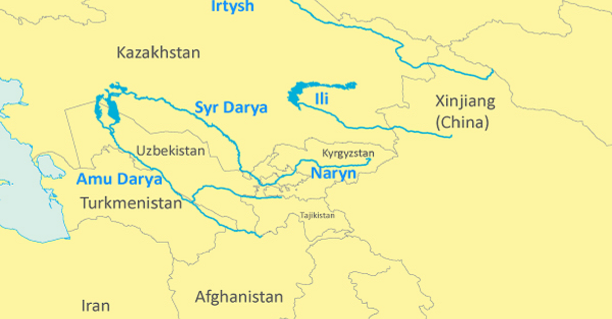
The Syr Darya is the longest river on the territory of Uzbekistan (2800 km), the basin area is 345 thousand km2, and water resources are on average 21.6 km3. 45% of the water of the Syrdarya is small river and soybean waters coming from the Naryn River, 16% from the Karadarya River and 39% from the right and left tributaries.
On the tributary of the Syr Darya Norin in the territory of the Kyrgyz Republic, the Tokhtagul reservoir was built. Its total water capacity is 19.5 km3. In terms of water availability, it ranks second in Central Asia after the Kapchigai reservoir on the river or (Kazakhstan). The task of this reservoir, built in the post-Soviet era, was to provide water to the irrigated lands of the Ferghana Valley, the Syrdarya and Jizzakh regions, as well as the territory of Kazakhstan, to constantly reserve excess water and supply it for irrigation in dry years.
In order to use large volumes of clean fresh water in the Syr Darya for irrigation, the Kazakh state is going to complete the construction of the Kuksaroy reservoir with a water volume of 3.0 km3 in the lower reaches of the Chordyn reservoir. From 2006 to the present, a small amount of water has been supplied to the reservoirs of the Arnasay swamp from the Chordyn reservoir. For this reason, the water of the Syr Darya practically does not enter the Aydar Lake. As a result, the water level in Aidar Lake has decreased by 1.5-2.0 meters over the past 6 years.
The Amu Darya is the deepest river in Central Asia, its length is 2540 km, and its area is 309 thousand km2. 74% of its water is generated in Tajikistan, 13.9% - in Afghanistan and Iran, 8.5% - in Uzbekistan.
At present, on the barbaric tributary of the Amu Darya, there is the NORAK HPP and a reservoir. The water volume of the Norak reservoir is 10.5 km3, in terms of water volume it is second only to the Tukhtagul reservoir. The transition of the norak reservoir to the energy regime may affect the water supply of Uzbekistan. In dry years, when there is little water, the flow from the Amudarya decreases by 5.0-6.0 km3. This could lead to water shortages on several million hectares of irrigated land in the republics of Uzbekistan and Turkmenistan. If the Rogun reservoir is put into operation, its capacity will be greater than the Norak reservoir and will be 12.4 km3. Due to these reservoirs, water disposal during the growing season reaches 22.2%, and in dry years, up to 30-40%. In addition to the Norak and Rogun HPPs on the Vakhsh River, SanGTU has projects to build 1-2 HPPs and increase the capacity of reservoirs on the Naryn River to 25 km3. At the same time, on the Pyanj River, which is the largest tributary of the Amu Darya, there are projects for the construction of the Rushanskaya, Dashtidzhumskaya, Verkhne-Amudarya and other hydroelectric power plants and reservoirs to collect 39.0 km3 of water and generate electricity from them.
The maximum use of the water of the Amu Darya is also in the plans of the neighboring state of Afghanistan. From the territory of Afghanistan, bordering at a distance of several hundred kilometers along the left bank of the Amu Darya, the Kunduz and several small rivers flow into the Amu Darya. The waters of the Kunduz River make up 8% of the annual water volume of the Amu Darya. Under an agreement signed in 1958 in the former Soviet Union, the Afghan state is required to use up to 9 km3 of water annually from the Pyanj and Kunduz rivers and some other tributaries. 9 km3 of water is 10% of the annual flow of the Amudarya. Now the Afghan state uses only 2 km3 of Amu Darya water per year.
From the above facts it is clear that the problem of water in Uzbekistan can only worsen from year to year. We cannot develop new lands for irrigation even when we receive water according to the quota agreed between Kyrgyzstan and Tajikistan, since they are spent on irrigating 4 million 220 thousand hectares of currently irrigated land and providing other sectors of the national economy.
In the future, water supply in the republic should be established on the basis of new scientifically based technologies, rational and economical use of available water resources. First of all, it is necessary to modernize the existing irrigation system and implement ways to drastically reduce water losses. According to experts, 25 to 40 percent of water is lost from water sources through canals and ditches until it reaches the irrigation field.
This loss occurs in channels, ditches by suction (filtration), evaporation, leakage and other means. A large amount of water is diverted from the fields of irrigated crops through ditches and collectors. Their volume is 28.0-33.0 km3 per year. This is more than half of the water used for irrigation. Thanks to the sewage flowing through these collectors, hundreds of large and small lakes have formed around the deltas of the rivers. The salinity of water discharged through these collectors ranges from 4 g/l to 12 g/l. They are considered unsuitable for irrigation. But the biggest challenge is to reduce the salt content in these large volumes of water, that is, the development of desalination technology. If a technology for desalination of saline wastewater is introduced or developed, then using these waters for irrigation will open the prospects for the development of another 2 million hectares of land.
Increasingly, there are opinions that the global climate change now taking place could lead to more glacier melt, which will eventually lead to a significant reduction in river waters, which begin with glaciers from permanent snows. Given this process in water use, we should now see ways to adapt to climate change.
The main decision on the use of the waters of transboundary rivers should be based on compliance with international legal norms, mutually beneficial agreements, considering the interests of neighboring states.
Elmurod Ulugmurodov,
Doctoral student of Samarkand State University.
Scientific adviser - Doctor of Geographical Sciences, Professor Ali Abdulkosimov.